skip to main |
skip to sidebar
 To escape the heat & give the hiking legs a rest, today we tried our hands at white water rafting on the Colorado River. The Colorado runs through the town of Moab, and there are a least a dozen adventure companies there that offer rafting and kayaking trips on the river ranging from half-day to 4 day expeditions. Most people opt for the larger 10-person rafts where the guide uses oars & does all the work, but we asked for the smaller "paddle-it-yourself" raft, that holds 6 enthusiastic paddlers (Mark & Heather in the front, Mike & Lindsey in the middle, a guy called Frank & his nephew in the back) and a guide (Scott) steering at the rear)
 Since Mike & Lindsey had never tried rafting before, we chose the 4 hour, 13 mile trip down one of the milder parts of the river (class I and II rapids), known as the Fisher Towers section - named for the prominent series of free-standing rock towers and cliffs through which the river flows. The water level in the river was very high due to the Spring snow melt upstream, and much of the trip was spent in the calm sections admiring the amazing scenery.
 Here's an action shot at one of the "more exciting" rapids. (Yes Heather & Lindsey got quite wet!) The four of us agreed that this was the most fun and next time we should opt for the more challenging Westwater Canyon or Cataract Canyon sections of the river.
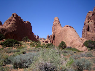 After a welcome picnic lunch, we headed further into Arches National Park to check out the Devils Garden area, which offers a variety of arches, fins, canyons and slickrock. At the start of the trail there are some very good examples of the sandstone fins from which the arches are eventually carved
.
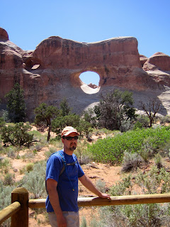 Our first stop is at Tunnel Arch, which can only be seen by hiking down into a sandy gully and looking back up towards the rock plateau from which we came.
 Here's Heather standing beneath Pine Tree arch, so named for the gnarled Pinyon pine growing in its opening.
 Looking up from beneath Pine Tree arch you can see how narrow the span of rock is.
 Mike, a keen photographer, views the arch through his camera lens, while Mark surveys it through his sunglass lenses.
 Here's a great shot Mike took of Mark looking at the arch (note the arch reflected in his sunglasses)!
 Not all erosion in the park causes arches, sometimes interesting columns and balanced rocks are formed. Here's Lindsey doing her impersonation of the rock column.
 In some places, the vegetation is just as interesting as the rocks. The crazy distortions of this juniper tree that sits in the middle of the trail were so unique they just had to build the fence around it!
 The turning point in our hike was at Landscape Arch, which with a span of 306ft (93m) is the largest arch in the park. Until recently visitors were allowed to walk under and around the arch but several rockfalls in the last few years have caused the area to be closed. The cleaner looking rock on the right-hand side of the arch is where the most recent rockfall occurred. The huge span is little more that 3ft (1m) thick at its narrowest point and has several lengthy fractures, so it may not survive as an arch much longer.
 With temperatures in the 90's again, after 5 miles and several hours of hiking the four happy hikers are hot and tired and ready to hit the jacuzzi back at our Bed & Breakfast in Moab!
 Ben loves travel and hiking as much as Mark & I do, so we decided to take him to Moab for a few days to get a taste of the American southwest.
 We arrived at Arches National Park around lunchtime. With the temperature forecast to go over 100F (38C) this afternoon, we decided we would only tackle a couple of short hikes - the first one to Balanced Rock.
 Ben is dwarfed by the 128ft (39m) rock formation. The hard Entrada sandstone "head" balancing on the softer, eroded Dewey sandstone "neck". The overhanging Entrada sandstone protects the softer sandstone beneath it from some of the effects of erosion, but eventually it will erode enough that the balancing rock will topple over.
 Our next hike was in The Windows section of Arches National Park. Here are Ben & Mark beneath Turret Arch.
 We then headed over to The Windows arches. If you click on this picture, the size of the people underneath North Window (the one on the left), will give some perspective on the size of these arches.
 Ben & I head up to North Window.
 View across the park through North Window.
 Our last stop for the day was Park Avenue - named for its resemblance to the tall high-rise buildings on Park Avenue in New York.


