skip to main |
skip to sidebar
 When I returned from Australia, my son Ben travelled with me for a 2 week vacation in the US. To help him acclimatize to the summer heat and altitude here in Salt Lake we went for a hike near our house along the Bonneville Shoreline Trail in Corner Canyon.
 Ben, who has previously only visited during the snows of winter, couldn't get over how different the area looked with leaves on all the trees.
 We headed back to Arches National Park this morning for a ranger-guided hike through the "Fiery Furnace". The Fiery Furnace is a maze of red and cream sandstone fins, pinnacles and narrow canyons. It was named by early pioneers who thought the fingers of rock, in the late afternoon sun, looked like flames in a furnace. Although our hike began in the bright morning sun, the outcrops still looked impressive.
 There are no marked hiking trails in the Fiery Furnace and people have often got lost in the maze of rocks so permits are required to go into this region of the park. Ranger Patrick was our guide for today's adventure. He started with a talk about the area we were about to enter and explained that we should be careful where we tread, sticking to the washes of dry streams and areas of bare rock so that we didn't damage the "cryptobiotic soil crust". Although it looks like bare soil, it contains tinay cyanobacteria, lichen, algae and fungi that combat erosion, absorb moisture and provide other nutrients for plant growth in this delicately balanced dry desert region.
 As we descended towards the dry "wash" in the first canyon it was amazing to see how much plant life was supported including this gnarled Utah Juniper which can live for 600 years.
 Our group of about 20 hikers heads into the first canyon.
 The walls of this narrow canyon seem to bend over us. The dark brown streaks on the salmon-colored walls are known as "desert varnish" which is formed by biochemical reaction of bacteria on the clay, black manganese and red iron oxides on the rock surfaces.
  "All eyes on Ranger Patrick". We take a rest in the shade in Raven Canyon as Patrick tells us about the small pool of permanent water called a "pothole" that contains a surprising amount of life and attracts native animals & birds. During infrequent thunderstorms this canyon becomes awash with water. The tall walls of the canyon provide enough shade that the water trapped in potholes like these is very slow to evaporate. Apparently this pool is a popular drinking spot for the local ravens.
 Apparently this pool is also a popular spot for the local ranger guides, who get a kick out of distracting their audience with the tales of the pool so that they fail to notice the spectacular Twin Arch (also known as Skull Arch) that is sitting behind and above them!
 As we explored deeper into the furnace we had to scramble over rock crevices...
 ... and through some narrow slot canyons that were a tight squeeze!
 The scenery was amazing...
 ... and clearly our intrepid hikers were up to the task!
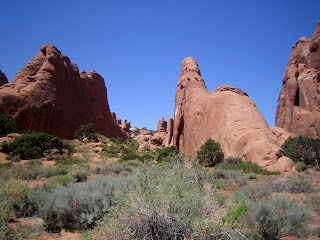
 We continued upward through the maze of rock fins and it was easy to see how one could get lost in this place with walls so tall there was no way to "see a way out".
 After scrambling through another narrow slot we came upon Surprise Arch.
 "I think the way out is through here..."
 The sun shining into the narrow canyons cast some interesting light on the salmon-colored rocks. Mike took this picture of Heather, whose orange shirt matched the glow of the walls.
 Even this lizard seemed to blend well with the colors of the rocks.
 In places the canyons were quite wide and dotted with vegetation. We loved the contrast of the green plants, red rock and blue sky.
 Here and there, spring blooming cactus added pretty decoration.
 After 3 hours of "exploring" we passed underneath the "kissing rocks"...
 ...and saw our way out of the Fiery Furnace.
 After a welcome picnic lunch, we headed further into Arches National Park to check out the Devils Garden area, which offers a variety of arches, fins, canyons and slickrock. At the start of the trail there are some very good examples of the sandstone fins from which the arches are eventually carved
.
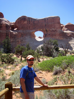 Our first stop is at Tunnel Arch, which can only be seen by hiking down into a sandy gully and looking back up towards the rock plateau from which we came.
 Here's Heather standing beneath Pine Tree arch, so named for the gnarled Pinyon pine growing in its opening.
 Looking up from beneath Pine Tree arch you can see how narrow the span of rock is.
 Mike, a keen photographer, views the arch through his camera lens, while Mark surveys it through his sunglass lenses.
 Here's a great shot Mike took of Mark looking at the arch (note the arch reflected in his sunglasses)!
 Not all erosion in the park causes arches, sometimes interesting columns and balanced rocks are formed. Here's Lindsey doing her impersonation of the rock column.
 In some places, the vegetation is just as interesting as the rocks. The crazy distortions of this juniper tree that sits in the middle of the trail were so unique they just had to build the fence around it!
 The turning point in our hike was at Landscape Arch, which with a span of 306ft (93m) is the largest arch in the park. Until recently visitors were allowed to walk under and around the arch but several rockfalls in the last few years have caused the area to be closed. The cleaner looking rock on the right-hand side of the arch is where the most recent rockfall occurred. The huge span is little more that 3ft (1m) thick at its narrowest point and has several lengthy fractures, so it may not survive as an arch much longer.
 With temperatures in the 90's again, after 5 miles and several hours of hiking the four happy hikers are hot and tired and ready to hit the jacuzzi back at our Bed & Breakfast in Moab!
 Our good friends Lindsey and Mike drove from Houston Texas to join us on this road trip. Today we headed to Arches National Park for some hiking (and of course to see the "arches"). Our first stop was a 3 mile hike to Delicate Arch (perhaps the most famous of the 2,000 arches in the park).
 The trail sets out across some sparse desert landscape and then climbs 500ft in elevation across salmon-colored Entrada Sandstone. If you click on this picture to enlarge it, you'll see tiny black specks that are people climbing across the rock. It's hard to get a true perspective of the size of these sandstone formations in a photo. (Use the Back button on your browser to return to the blog after looking at the pic)
 At the start of the hike, we pass the restored remnants of Wolfe Ranch. The 100 acre ranch was settled in the late 1800's by a civil war veteran who moved west to the drier climate seeking relief from his war wounds. Wolfe, his oldest son, his daughter and her husband lived in this small one-room cabin with separate storehouse, raising cattle. Can you imagine living in such a remote place? They lived here for a little over 20 years, before selling the ranch and returning to Ohio.
 As we climb up the sandstone trail, we pass hollows filled with vegetation and catch glimpses of some small arches. (To qualify as an arch the opening must be at least 3 feet across, carved in one section of rock, and daylight must be visible through the opening).
 We also encountered this leopard lizard.
 Finally, as we near the top of the trail we scramble up to an interesting opening, only find it offers a "sneak peak" at our destination, Delicate Arch - a good spot for a photo of Mike, Heather and Mark!
 Here we are rounding the final corner of the trail. It's hard to gauge depth from the photo, but there was quite a drop-off from this ledge.
 The forces of wind and water erosion are amazing. Delicate Arch seems to be perched on top of a bowl of red sandstone.
 To give you some perspective of the size of the arch, here are Mike, Lindsey and Mark standing beneath it!
 On our return to the carpark, a short detour on a side-trail took us to view some ancient pictograhps carved in the rock. Known as the Wolfe Ranch Panel, this rock art depicts a Ute Indian hunting scene, with riders on horseback and their prey - big-horned sheep.
 When I returned from Australia, my son Ben travelled with me for a 2 week vacation in the US. To help him acclimatize to the summer heat and altitude here in Salt Lake we went for a hike near our house along the Bonneville Shoreline Trail in Corner Canyon.
 Ben, who has previously only visited during the snows of winter, couldn't get over how different the area looked with leaves on all the trees.


