Thursday, October 30, 2008

tibble fork reservoir

We haven't been up to much of interest lately, so today Mark & I headed up nearby American Fork Canyon for some exercise and fresh air. We did a short hike along Tibble Fork Reservoir. This 13 acre reservoir is a popular fishing and camping spot. There was quite a bit of glare coming off the lake in the late afternoon sun. This shot is looking south down the reservoir towards Mt Timpanogos.

There weren't many other people around but we did see a couple of fly fisherman trying their luck at the northern end of the lake.

Saturday, October 25, 2008

pumpkin carving

Next Friday (Oct 31st) is Halloween. So in keeping with the "spirit" of the occasion (and because it's a novelty for an Aussie), we carved ourselves a Jack-o-Lantern.

First cut the top off one large, orange pumpkin.


2. Scoop the seeds and soft flesh (the "brains") out.

3. After tracing a "face" on the skin, carve the pieces out.

Voila! One goofy looking Jack-o-Latern

4. Place pumkin outside in the Halloween display.

6. Wait for dark to "light the lantern".

Sunday, October 19, 2008

first snow

We got our first snow of the season at the house last week. It started snowing overnight & I'd say we ended up with about 2 to 3" on the ground. This is the view out of our back sliding door. The patio table has a pretty good cover of snow. You can't see the mountains because of all the low cloud. The snow didn't stick around for long though. Temperatures this week have been back up in the 70's (20's celsius). Bit confusing for the plants that haven't lost their leaves yet. The marigolds and zinneas have been brought to a premature end although the cold doesn't seem to bother the pansies - even after being buried in snow!

Monday, October 6, 2008

road trip to colorado - day 4 - dinosaur national monument

We spent the night at Mariposa Lodge, a lovely bed & breakfast in the western Colorado ski resort town of Steamboat Springs. On Monday morning we did a quick tour of the town & ski area then headed west again on Hwy 40. Just over the Colorado/Utah border we made a stop at Dinosaur National Monument. This 200,000 acre national park contains the largest number of Jurassic period dinosaur bones ever discovered.

In 1909, palaeontologist Earl Douglass found 8 segments of the tail of an Apatosauras (aka Brontosaurus) at the top of a steep sandstone cliff. Over 350 tons of plant and animal fossils including some full skeltons were excavated in the early years. Declared a national monument in 1915, fossils are still being extracted from this area today.


The visitors center at the park looks like it is growing out of the mountainside because it is! One entire wall of the center is comprised of a natural rock face still embedded with 1500 exposed dinosaur fossils. Unfortunately, the visitor center is currently closed because of subsidence of the unstable ground on which the building sits. However, there are other places in the park where exposed fossils can still be viewed in the rock faces, so Mark and I set off on a short hike to see them.


Scientists believe that about 150 millons years ago the area was a river basin frequented by dinosaurs. Dinosaurs that died near the river or were caught in floods were swept downstream, caught on sandbars and were covered by subsequent layers of sand and mud, that compressed to form sedimentary rock and sandstone. About 65 million years ago those layers were gradually uplifted and slowly eroded to reveal the rock faces we can see today.

In the center of the pic above, you can see the exposed fossil of dinosaur vertabrae or backbone.


Further along the rock face lies this exposed femur (leg) bone. Eleven different species of dinosuars have been found in this rock formation including apatosaurus, stegosaurus, allosaurus, certaosaurus and diplodocus.
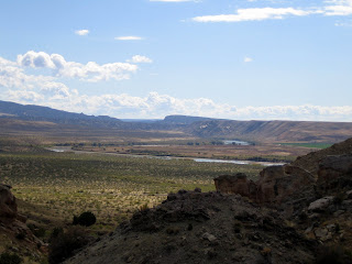
Today the area is again a part of a river basin. Here's a view from the dinosaur quarry down over the Green River Valley.


The sandstone rock faces in the park also contain numerous petroglyphs left by the Freemont indians approx 1000 years ago. In the pic above there's a elk-like creature just off my right shoulder and a basket or head-piece high above my head.


After a short stop for lunch in Vernal, we headed home through Heber Valley to find that Mt Timpanogos had received its first snowfall for the season.

Sunday, October 5, 2008

road trip to colorado - day 3 - rocky mountain national park

On Sunday we headed to Rocky Mountain National Park, about an hour's drive NNW of Boulder. The plan was to take a "more scenic" route home.


As we first entered the park we encountered this herd of elk. It is currently elk mating season so elk encounters are more common as they descend from the high country to the lower meadows to mate.


The Trail Ridge Road that crosses over the mountains through the park is normally only open from June to mid-October. Unfortunately an early October storm arrived the night before our visit bringing rain & sleet that froze to ice and closed the road. A ranger at the park visitor center suggested that since today was sunny and warm they might open the road again that afternoon if the ice on the road had melted. We had planned to do some sight-seeing and hiking in the park anyway so we chose a 6 mile hike to Mills Lake. The trail started at 9,475ft elevation climbing 750ft to Mills Lake. The following slide show covers this hike. The trail follows Glacier Creek up Glacier Gorge past Alberta Falls. The final pic is looking south across Mills Lake towards Longs Peak (the highest mountain in the park at 14,259ft). The small jagged spires trailing back from Longs Peak (on the left) are called the Keyboard of the Winds, named for the musical sound the wind sometimes makes as it blows across the rock spires.


After returning from Glacier Gorge, we picked up some food from the car and then took another short hike to Bear Lake to eat. This is the view we enjoyed while eating our picnic lunch.


There had been no sign of bad weather all morning, so after lunch we set off on the drive across the mountains. Eventually the road climbs above the treeline. We stopped at Forest Canyon Overlook (11,700 ft)...


... taking in the view south east down Forest Canyon across the park towards Longs Peak.


This area of alpine tundra (a Russian word for "land of no trees") is under snow for most of the year. Winds often exceed 100mph (160km) and temperatures remain below freezing for at least 5 months of the year. Only a few grasses and alpine wildflowers can survive these harsh conditions and the short growing season. If you look closely in the picture below you can see a couple of cars on the road as it heads up the mountain towards the highest point on the road at 12,183ft.


As we reached the top of the climb the clouds and weather closed in and it started to sleet. As we descended, the weather began to clear until around 9,000ft we were back in sunshine again and encountering more herds of elk.


At the western entrance of the park, a series of 3 lakes - Grand Lake, Shadow Mountain Lake & Lake Granby have been created on the upper reaches of the Colorado River.


I love the light in this picture with the late afternon sun on the lake and the stormy looking clouds hovering over the Rocky Mountains that we have just crossed. Shadow Mountain Lake seems well-named!

Saturday, October 4, 2008

road trip to colorado - day 2 - football

On Saturday evening we headed out for "the big event" i.e. the football game between the University of Texas Longhorns (Mark's alma mater) and the Colorado University Buffaloes. From our hotel in Boulder we waited at a nearby bus stop for a shuttle to take us to the game. Interestingly the Texas fans (in burnt orange) outnumbered the Colorado fans (in gold and black) at this stop.


Although he follows the college football every weekend, Mark hasn't been to a "live" UT game in nearly 20 years. There are 119 teams in Division 1A of college football in the US, so teams don't get to play every other team. This Texas game being played in Colorado is the closest geographically to where we live and was the main "inspiration" for our Colorado trip. We had great seats in Row 19 on the 40 yard line. We arrived at the game early, in time to see the teams on the field for their "warm ups".


Even the "big men" know how to stretch. Texas quarterback Colt McCoy is in the center of this pic wearing #12. At 6ft 3" and 205lbs he's one of the "smaller" guys on the team!


After the warm-ups, the players left the field and the Colorado marching band entertained us for about 15 minutes before playing the national anthem.

Next it was time for the Colorado Buffaloes mascot "Ralphie" to take a spin around the field. Despite her name, Ralphie is actually a female (because female buffaloes are smaller and less agressive). Ralphie does a lap of the field before each half at Colorado home games. She runs around the field at speeds up to 25 mph (40km/h) and it's amazing watching her 5 student-athlete handlers trying to keep up! The Texas Longhorns have a longhorn steer called Bevo as their mascot, but I have to say that Ralphie might top Bevo as the coolest team mascot.


The stands were now full (53,927 spectators) and with all the hoopla over, the teams finally took the field. Boy football teams here have a lot of players!


Colorado were the first to receive. This is the first play. I know there's a football in there somewhere!


Here's a couple of happy fans at the end of the game. The final score? Texas won 38-14. Texas is currently ranked #5 in the nation. Next week they play Oklahoma the #1 ranked team. Should be an exciting game. HOOK'EM HORNS!

road trip to Colorado - day 2 - Boulder

On Saturday morning we headed into "downtown" Boulder to check the city out. Boulder lies at 5,430ft in the foothills of the Rocky Mountains approx 35 miles northwest of Denver. It was established in the late 1850's as a supply town to the miners who were heading into the mountains in search of gold and silver. Today it has a population of 92,000 (280,000 in the greater Boulder Metropolitan area) and is home to the main campus of the University of Colorado with an enrollment of approx 30,000 students. Mark and I both really liked the feel of the city. The heart of downtown is the Pearl Street Mall - a wonderful tree-lined pedestrian mall that covers 4 blocks with an eclectic assortment of clothing & shoe stores, arts & crafts stores & gallery's, cafe's and restaurants.


We also took a walk around one of the older suburbs adjoining downtown. We loved the peacefulness of the old houses and the tree lined streets that were just blocks from "the action" on Pearl Street.


We headed back to Pearl Street for lunch and enjoyed a local brew and tasty meal at BJ's on the mall, sitting at a sidewalk table listening to some street musicians and people watching. Here's a shot of me "playing" in the bubblejet fountain in front of the Boulder Court House (also on Pearl St).

Friday, October 3, 2008

road trip to Colorado - day 1 - Wyoming

As our birthday present to each other, Mark & I decided to do a 4-day road trip to Boulder, Colorado, to see parts of the country we haven't seen before and to take in a Texas Longhorns (college football) game being held in Boulder. We set out on Friday morning heading north east from Salt Lake City, taking the Interstate highway (I80) across Wyoming to Cheyenne, before turning south to Boulder. Southern Wyoming is very sparsley populated. Close to the Utah border the scenery has some interesting cliffs and rock formations, but as we travelled east across the state I have to say that the countryside is mostly flat, treeless and un-interesting (see pic below).

The only visual relief were the many windmills along the way. (If you look closely you'll see over 20 of them on the ridgeline in the pic above). Wyoming is one of the largest producers of wind energy in the US. Aparently an area of "high wind energy" extends across southern Wyoming from the Utah border on the west to the Nebraska border on the east. "This zone of high wind energy can be attributed to a major gap about 90 miles wide (150km) in the north-south barrier of the Rocky Mountains. Prevailing westerly winds blow with little resistance through this gap across the relatively high plains." We certainly saw many wind farms on the 360 miles (580km) we travelled across Wyoming.